
Madrid is one of the largest and busiest capitals in Europe. It currently has a population of more than 3.2 million, and an estimated 12 million trips occur daily on its streets and avenues. Given this scenario, it is essential to have tools and technologies that enable the measurement, analysis, and improvement of urban mobility.
The Madrid City Council put out to tender a service contract to obtain and process real-time mobility data, collect real-time information, and improve traffic planning and management.
To this end, a Big Data platform has been developed: SIDERA Analytics, which integrates information from different sources: sensors and measurement devices at strategic points in the city, such as essential intersections and main traffic arteries; mobile phone data, GPS devices integrated into vehicles, databases of the Municipal Transport Company (EMT) and the Madrid Regional Transport Consortium (CRTM), etc. All the data that, after processing by the Big Data platform, reveals vehicle density, travel times, and citizens’ movement patterns, among other aspects relevant to understanding urban mobility.
This project aims to understand citizens’ mobility patterns and, as a result, improve and organise travel modes. Obtaining detailed information on the most frequent traffic incidents enables you to automatically identify traffic-congestion points or areas with traffic regulation violations, allowing authorities to respond more quickly.
This solution, developed by SICE, provides the Madrid City Council with tools and information to plan the city more efficiently, enabling decisions based on thousands of data points that inform urban planning, infrastructure design, and the management of public services.

The Big Data SIDERA Analytics platform integrates various City Hall services, including data collected through City Hall traffic technologies. For example, it offers within its GIS viewers relevant information such as the number of accidents recorded by the Municipal Police, which allows analysing the areas of the city with the highest incidence of accidents and taking measures to improve road safety:

It also provides the number of vehicles entering and leaving Madrid each day, which is very useful for understanding city traffic and making informed decisions.

These are just some examples of how using information collected through this platform enables us to gain a comprehensive, detailed view of city mobility, leading to better traffic planning and management and more efficient, sustainable mobility for all citizens.
One of the main components of the service contract for obtaining and processing real mobility data in the city of Madrid is the information obtained through mobile telephone antennas obtained by SICE from the Mobile Network Operators. This information source helps collect data on road traffic and private-vehicle trips, as most citizens carry mobile devices. The data is anonymised, guaranteeing the privacy of citizens and complying with the LOPD, since no personal information is collected, but only mobility data.

The information collected through mobile telephone antennas enables us to determine the number of vehicles circulating in each neighbourhood or district, the most frequently used trips by citizens, and the main origin-destination flows between neighbourhoods or municipalities. Destination in the city of Madrid. This allows telephony data to be disaggregated and displayed alongside other sources, such as data from public transport operators (EMT or CRTM).
Another vital source of information is the EMT and CRTM databases. These two public entities are responsible for public transport in the city and the Autonomous Community of Madrid, respectively, and therefore have detailed information on passenger numbers, service frequency, routes and stops, among other aspects.
Integrating this information into the Big Data platform enables us to gain a comprehensive view of city mobility, covering both road traffic and public transport. In this way, it is possible to identify the highest-demand areas for public transport and develop public policies that encourage its use, such as by creating new transport lines, expanding service offerings, or improving accessibility.


The permanent capacity stations of the Madrid City Council are another vital source of information for the service contract to obtain and process real mobility data in the city of Madrid. These stations are located across the city and measure the number of vehicles circulating on a given street. These stations are divided into three types: motor vehicles, bicycles and pedestrians.
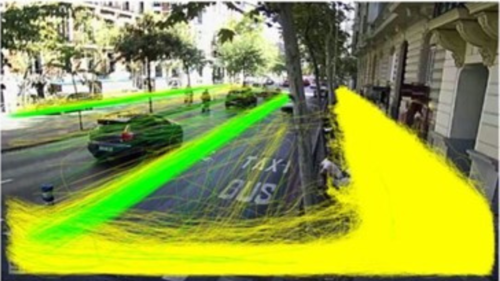
Recently, a new Artificial Intelligence-based technology has been developed that enables the identification of mobility type, i.e., whether it is a motor vehicle, a bicycle, or a pedestrian. This technology can process images captured by the permanent gauging stations and simultaneously store the trajectories of identified vehicles.
Note that although all these stations use cameras to collect information, they do not record video; they process images and store and transmit only data. In this way, the privacy of citizens is guaranteed, since no personal information is collected, but only mobility data.
AI-based image detection technology enables you to gain detailed insights into urban mobility, including vehicle types and each vehicle’s trajectory. As a result, traffic planning and management can be improved.

The information collected by these permanent gauging stations is especially valuable for analysing bicycle and pedestrian mobility, as these users are often more challenging to measure than motor vehicles. Thanks to this new technology, it is possible to obtain detailed information on these users’ mobility, enabling improved planning and management of public spaces and promoting safer, more accessible mobility for all citizens.
Mobility is a crucial issue in urban planning and city management in Madrid. To make informed decisions on mobility policies, it is necessary to have accurate, up-to-date information on citizens’ mobility patterns. In this sense, this service contract from the Madrid City Council is an innovative initiative that uses cutting-edge technology to collect valuable information on citizens’ movements.
(Images – SICE)